
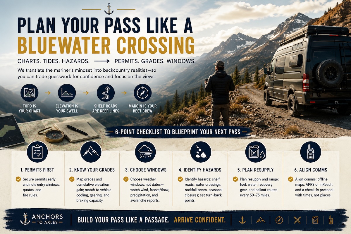
Route Planning Reimagined: From Nautical Charts to Mountain Pass Itineraries You Can Trust
On the water, bad planning can put you on a sandbar. In the mountains, it can put you on the wrong side of a pass in a snowstorm with 18,000 pounds of truck and trailer staring down a 7% grade.
Same stress. Different terrain.
At Anchors to Axles, we live in both worlds. Years of planning routes for a 74-foot Hatteras motor yacht are now feeding directly into how we plan RV routes, mountain passes, overland trails, and long-haul road trips. The systems look different on paper, but the logic is almost identical.
Here’s how we’re turning nautical charts, tides, and hazards into national park permits, elevation grades, and weather windows for land-based itineraries you can actually trust.
Step 1: Charts vs. Maps – Stop “Winging It”
On the water:
- We study NOAA charts, soundings, markers, and AIS.
- We plan routes in software, but always cross-check with paper.
- We know our depth, air draft, and fuel burn at different speeds.
On the road:
- Most people punch an address into Google Maps and hope for the best.
That’s the first mistake.
For RVs, tow rigs, or overlanding builds, you need the road equivalent of charts:
- RV-safe navigation apps (RV Life, CoPilot, Garmin RV)
- Topographic maps for elevation, passes, and grades
- National park and BLM maps for access roads, length limits, and dispersed camping zones
Treat your rig like a boat with a draft and a mast:
- Height = your air draft
- Length + toad/trailer = your LOA (length overall)
- Weight and braking = your maneuvering and stopping distance
If the road (or campsite) “chart” doesn’t match your specs, it’s not your route.
Step 2: Tides Become Permits and Time Slots
On a yacht, tides and currents dictate everything:
- Bridge clearances
- Inlet conditions
- Fuel burn against or with the current
- Whether you’re arriving at slack water or a mess of standing waves
On land, the equivalent is permits, reservation windows, and timed entries.
Think of it like this:
- Nautical tide window = National park timed entry
- Slack water at the inlet = “Must be at the trailhead by 6 a.m.”
- Current against you = driving into a tourist town at check-in time on a Saturday
For mountain pass itineraries, that means:
- Booking entry windows for parks (Glacier, Rocky Mountain, Yosemite) before you design your driving days.
- Lining up campground check-in/out times so you’re not stuck hunting for parking with a 30–45-foot setup when everyone else is doing the same thing.
- Planning trail days like tide windows: you’re moving early, you hit the peak at the right time, you’re off exposed ridges before the afternoon storms roll in.
Instead of asking “When do we want to be there?” start asking “When can we safely and legally be there?” Then build the itinerary backwards—just like planning an inlet entry on the right tide.
Step 3: Hazards to Avoid – Rocks, Shoals, and 10% Grades
On charts, hazards are obvious: depth contours, wreck symbols, shoals, bridge heights, restricted areas.
On the road, hazards are less clearly marked, but just as real:
- Sustained 6–10% grades with limited pullouts
- Tight switchbacks with no bailout if you misjudge your turning radius
- Unpaved forest roads that turn into axle-breaking ruts after a storm
- Low clearances (tunnels, old bridges, gas station overhangs)
Our water-to-road hazard checklist looks like this:
Know your numbers (non-negotiable):
- True height (with AC units, antennas, solar, and racks)
- Length with trailer or toad
- Actual loaded weight, not the fantasy spec sheet
- Braking capability and transmission temps on climbs/descents
Use tools that show the “underwater rocks”:
- Apps with truck/RV routing that avoid low clearances and weight-restricted bridges
- Topo layers that clearly show elevation gain and grade
- State DOT sites showing chain laws, closure histories, and construction zones
We learned this the hard way: following a “scenic” route recommendation from a standard maps app and ending up on a narrow mountain road with no shoulders and a drop-off that didn’t care about our YouTube thumbnail dreams.
On the water, you never cut a corner across an uncharted shoal. On land, don’t “shortcut” a pass just because the app says it’s 12 minutes faster.
Step 4: Weather Windows – Fronts vs. Forecasts
Marine forecasts rule everything: wind direction, sea state, fronts, thunderstorms, fog.
For mountain passes, the same weather mindset applies:
- Check multiple forecasts, not just the one in your weather app.
- Pay attention to wind advisory days that can turn a high bridge or exposed pass into a white-knuckle experience.
- Respect shoulder seasons: a sunny afternoon can still start with black ice on a north-facing slope.
Our process now:
- Look at the five-day window for temperature swings, precipitation, and wind.
-
Plan big-pass days when:
- Wind is manageable
- Temps aren’t flirting with freezing at altitude
- No major systems are rolling through
On the yacht, we wait for weather windows for offshore hops. With a truck and trailer, we wait for weather windows for the big climbs and descents. Same patience, different risk profile.
Step 5: Fuel, Range, and Bailout Plans
Cruising on a 74-foot motor yacht taught us to obsess over range and bailout points:
- Where’s the last good fuel dock?
- Where can we safely anchor if the weather turns?
- How much reserve do we keep in the tanks?
Translating that to a mountain pass itinerary:
- Don’t roll into a pass with 1/8 tank “because the map says there’s fuel on the other side.”
- Assume at least one gas station will be closed, out of diesel, or RV-unfriendly.
- Keep an eye out for turnouts and runaway truck ramps before you need them.
- Identify “safe bailouts” on the map: lower-elevation campgrounds, wide pullouts, or towns you can stop in if weather turns early.
Range anxiety feels different in a truck than on a yacht, but the solution is the same: know your burn, know your options, and never plan your day down to the last mile or the last gallon.
Step 6: Reality Check – Build Margin for the Chaos
No matter how much you plan, life fills in the gaps:
- A semi blows a tire on the grade.
- A rockslide closes your chosen road.
- Your rig runs hotter than expected on long climbs.
- The “easy” campground entrance has a surprise 90-degree turn with a ditch on both sides.
On the water, we build time and fuel margins. On the road, build:
- Time margin: don’t stack a major pass, a permit window, and a long driving day on the same 8-hour block.
- Energy margin: plan shorter days when you know the driving will be mentally intense.
- Mechanical margin: stop early if something feels off—smells, temps, braking performance.
Perfect itineraries look good on a spreadsheet. Real ones leave room for the unknown.
Bringing It All Together
When you plan a mountain pass itinerary like a captain plans a coastal passage, you stop “going for a drive” and start running a route:
- Maps instead of charts
- Grades instead of depths
- Permits instead of tides
- Weather windows instead of forecast screenshots
- Pullouts instead of anchorages
The terrain changes, but the mindset doesn’t.
If you’re ready to take your boating brain and put it to work on the road—or level up your RV route planning with a mariner’s discipline—Anchors to Axles is built for exactly that crossover life.
Want help turning your next route into a real plan, not a guess? Follow along with Anchors to Axles for detailed breakdowns of actual routes, what worked, what broke, and how we keep both the yacht and the rig moving toward the next horizon.